Neven Matasovic, M.EERI, Edward Kavazanjian, Jr., M.EERI, and Robert L. Anderson
Interpretation and analysis of observational data on the performance of solid waste landfills during earthquakes is the most reliable source of information on the seismic response of solid waste landfills. The data from several major California earthquakes indicate that the general performance of landfills during earthquakes is from good to excellent. None of the landfills on which observational data is available experienced major earthquake-induced damage. Recorded strong ground motion data indicate that amplification of both peak and spectral accelerations can occur at the top of a landfill. This, combined with the fact that only a limited number of landfills with geosynthetic liners and no landfill with a geosynthetic cover have been subjected to strong ground motions, indicate that attention to detail is warranted in the design of modern, geosynthetic-lined and/or covered landfills in areas of high seismicity.
INTRODUCTION
Observations of the performance of solid waste landfills during earthquakes
provide the most reliable means of identifying modes of damage for which seismic
performance analyses are required. Observations of seismic response are also
valuable for calibrating performance analyses that are developed to address
identified modes of damage. Ideally, the calibration of seismic performance
analyses employs case histories where material properties and physical conditions
are well-established, where instrumented recordings of performance during the
event exist, and where secondary or combined effects do not lead to ambiguous
interpretations of performance. Realistically, in geotechnical practice, few
case histories of any kind and no landfill case histories meet these ideal requirements.
Despite the lack of such ideal case histories, observations of the performance
of solid waste landfills in past earthquakes represent the most important source
of information for design of modern landfills to resist seismic loading. This
paper critically summarizes the existing observational database of the response
of solid waste landfills in California to strong ground motion, providing interpretation
of the observations of damage and recorded data. Characterization information
on the California landfills discussed herein, including data sources and the
methodology employed for damage assessment, is also provided in order to facilitate
the application of the California experience elsewhere.
LANDFILL DAMAGE CATEGORIZATION SCHEME
Most California landfills for which observational data on seismic, performance are available have been canyon fill type landfills (i.e., landfills where a canyon is filled with waste across the breadth of the canyon partially or completely). Several earthquake-impacted landfills have been of the area fill type, where waste is placed on a broad flat base and excavation is limited to that necessary to install features such as leachate collection systems, toe berms, and/or liners. Several of the older landfills for which observational data are available were of the pit fill type, once a popular method to reclaim sand and gravel pits wherein the excavated pit is filled with waste. A fourth type of landfill in the observational database is the side hill fill type, wherein landfilling occurs against the side of a hill or ridge. In addition to landfill type, the earthquake-impacted California landfills differ in containment system details such as liners, covers, and leachate collection and removal systems (LCRSs). The inclination of active and interim waste slopes at California landfills is typically between 2H:1V (horizontal to vertical) to 3H:IV. At closed landfills, waste face slopes are typically 2H:1V or flatter. Solid waste landfills generally have a surface water control system that includes water conveyance and storage structures and may also have ancillary structures for temporary storage of hazardous materials, leachate treatment, and gas control.
Municipal solid waste disposed of in the major metropolitan areas of California has the following typical composition (by volume): demolition and construction waste (29%), residential waste (39%), commercial waste (21%), industrial waste (5%), miscellaneous waste (3%) and non-hazardous liquid waste (3%) (Matasovic et al., 1995a). Sewage sludge, occasionally disposed of at solid waste facilities, forms less than 1% of the total waste volume. However, these percentage may vary significantly at specific landfills. Disposal of non-hazardous liquid waste in solid waste landfills was banned in California in 1985 and therefore liquid waste can be found only in older solid waste landfills. Furthermore, due to California regulations which require that municipal solid waste be covered daily with at least 150 mm of soil cover and that an interim soil cover of at least 300 mm be placed periodically, the soil content of solid waste in California landfills is generally at least 20 percent. In some older landfills, after decomposition of putrescible materials, biodegradation, and settlement, soil content may be 50 percent or greater.
The five-level landfill damage categorization scheme employed in this paper was originally proposed by Matasovic et al. (1995a) in their study of landfill damage after the 17 January 1994 Northridge, California earthquake. This damage categorization scheme is presented in Table 1. Even though the contents of Table 1 are self explanatory, it should be noted that neither the "Moderate" (Level III) nor "Significant" (Level IV) categories imply a release of contaminants to the environment or impairment of the waste containment system.
Consistent with typical post-earthquake damage surveys, peak horizontal ground acceleration (PHGA) is used herein as the index of the intensity of earthquake loading. All PHGAs presented in this paper were estimated for a hypothetical bedrock outcrop at the approximate center of the landfill site. The Idriss (1993) attenuation relationship, shown by Stewart et al. (1994) to give reliable estimates of PHGA for recent California earthquakes, was used to estimate most of the PHGA values presented in this paper. For sites located directly above the hanging wall of a thrust fault, PHGA estimates by the Abrahamson and Silva (1997) attenuation relationship are provided.
Table 1. Damage categories for solid waste landfills (Matasovic et al., 1995a)
| Damage Category |
Description |
|---|---|
| V. Major Damage |
General instability with significant deformations. Integrity of the waste containment system compromised. |
| IV. Significant Damage |
Waste contaim-nent system impaired, but no release of contaminants. Damage cannot be repaired within 48 hours. Specialty contractor needed to repair the damage. |
| III. Moderate Damage |
Damage repaired by landfill staff within 48 hours. No compromise of the waste containment system integrity. |
| II. Minor Damage |
Damage repaired without interruption to regular landfill operations. |
| I. Little or No Damage |
No damage or slight damage but no immediate repair needed. |
OBSERVATIONAL DATABASE
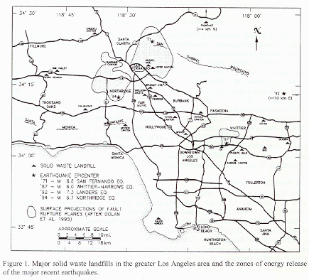
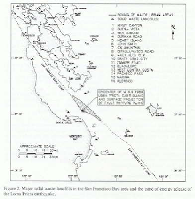
The observational database of California solid waste landfill response to strong ground shaking in recent earthquakes includes near- and intermediate-field data collected after the six major nearby earthquakes shown in Table 2 and data from several small magnitude or distant (far-field) earthquakes. The major earthquakes considered in this study are characterized in Table 2. The magnitudes cited in Table 2 and throughout this paper are moment magnitudes, M. All of the earthquakes characterized in Table 2 occurred in the vicinity of the two major metropolitan areas of California, the greater Los Angeles area and the San Francisco Bay area. Figures 1 and 2 show locations of the solid waste landfills for which this post-earthquake observational data exists. Figure 1 also shows the epicenters for the 1971 San Fernando, 1987 Whittier-Narrows, and 1994 Northridge earthquakes along with the corresponding surface projections of the fault rupture planes delineated after Dolan et al. (1995). The epicenter of the 1992 Landers event is approximately 110 km east of the limit of Figure 1. The 1989 Loma Prieta earthquake fault plane shown in Figure 2 is delineated in accordance with USGS (1989). The epicenters of the 1969 Santa Rosa earthquakes are approximately 35 km north of the northern part of Figure 2.
Table 2. Main characteristics of strong earthquakes from 1965 to 1994 in the
vicinity of major urban areas in California.
| Earthquake | Moment Magnitude | Style of Faulting |
|---|---|---|
| Santa Rosa (1 October 1969) |
5.6 and 5.7
|
Right Lateral
|
| San Fernando (2 February 1971) |
6.6
|
Reverse and Left
Lateral |
| Whittier-Narrows (1 October 1987) |
6.0
|
Reverse
|
| Loma Prieta (17 October 1989) |
6.9
|
Thrust and Right
Lateral |
| Landers (28 June 1992) |
7.3
|
Right Lateral
|
| Northridge (17 January 1994) |
6.7
|
Blind Thrust
|
Santa Rosa Earthquakes
The Redwood Landfill in Marin County, California, is probably the
first solid waste landfill in California for which earthquake-induced
damage was reported. As cited in Anderson (1995), in the 1969 M
5.6 and 5.7 earthquakes that occurred on a right lateral fault near
Santa Rosa, California, approximately 35 km from the Redwood landfill,
a few interior cell walls made up of clay (San Francisco Bay Mud)
collapsed but the perimeter berm around the landfill was not damaged.
The damage may have occurred due to amplification of the earthquake
motions by the underlying soft sediments, as the estimated PHGA in
bedrock at the site from these events is only 0.05 g.
San Fernando Earthquake
The main shock of the M 6.6 1971 San Fernando earthquake occurred as
reverse (thrust) motion on a buried fault. Oakeshoff (1975) provides a cross-section
through the San Fernando fault rupture plane indicating that the rupture started
approximately 13 km deep and propagated to the ground surface. The surface faulting
had both thrust and left-lateral motions. At the time of the earthquake, eleven
major landfills were located within a 60-km radius of the epicentral region.
One landfill was directly above the fault rupture plane. No strong motion recordings
were obtained during this earthquake on any of these landfills. However, many
recordings on rock and soil sites were obtained during this earthquake at distances
ranging from about 10 to 80 km. Based on these recordings, levels of shaking
(in weak bedrock) at the eleven landfills ranged from 0.05 g to 0.5 g.
A relatively small and, at the time of earthquake, closed landfill, the Russell Moe Landfill, was directly on the hanging wall of the San Fernando fault rupture plane and less than 1 km from surface manifestations of fault rupture. The estimate by the Abrahamson and Silva (1997) attenuation relationship indicates that bedrock PHGA could be as high as 0.9 g at the site. Barrows (1975) reports cracking around the boundaries of the Russel Moe landfill. Interviews with long-time residents of a trailer park located on top of the landfill report eruption of landfill gas fires at the location of cracks in the cover soil following the earthquake (personal communication, E. Kavazanjian, Jr.). The Russell Moe Landfill had no gas collection system and prior to the earthquake landfill gas was flared at the end of passive vents in the soil cover referred to by the residents as "Tiki" flares.
The Russel Moe Landfill is immediately adjacent to the Lopez Canyon Landfill. However, the Lopez Canyon Landfill was not yet established in 1971. At the time of the earthquake, the nearest major landfill to the San Fernando earthquake fault rupture plane was the North Valley Landfill, now called the Sunshine Canyon Landfill. This landfill was approximately 13 km from the fault rupture plane. Ten other major landfills were located from about 23 km (the Scholl Canyon Landfill) to approximately 65 km (the Palos Verdes Landfill) from the fault rupture plane. The San Fernando earthquake bedrock PHGA estimated for the Sunshine Canyon Landfill is approximately 0.30 g and for the Scholl Canyon Landfill is approximately 0.19 g (Idriss, 1993 attenuation relationship).
No documentation of systematic investigations conducted at any landfill site following the San Fernando earthquake is available. Interviews with the key personnel of both owners and consultants involved in the Sunshine Canyon and Scholl Canyon facilities indicate that cracking of cover soils was observed at both facilities. However, for the Sunshine Canyon Landfill reports of damage are contradictory. The Owner reported no damage while the Consultant reported some failure in the soil cover after the earthquake and cited unsubstantiated reports of three long parallel cracks on the east side of the landfill. The above data suggest that cracking of cover soils was the primary type of damage that occurred to landfills in the San Fernando earthquake.
Whittier-Narrows Earthquake
The main shock of the Whittier-Narrows earthquake occurred as a reverse motion
on a buried fault at an approximate depth of 10 to 14 km with no surface expression
of fault displacement. Davis et al. (1989) provide a cross-section through the
Whittier-Narrows earthquake fault rupture plane. Performance information is
available from five unlined landfills within 15 km of the zone of energy release:
the Operating Industries, Inc. (OII), Puente Hills, Savage Canyon, BKK, and
Azusa Landfills. The OII Landfill was the closest landfill to the epicenter.
The OII Landfill is a solid waste landfill that was operated between 1948 and
1984 and from 1976 to 1983, the OII Landfill received large quantities of liquid
industrial waste for "co-disposal" with municipal solid waste.
The cross-section from Davis, et al. (1989) enables a relatively accurate estimate of the site-to-source distance for the OII Landfill, and other landfills, to be made. For the site-to-source distance of 11.5 km for the OII Landfill estimated from the Davis et al. (1989) cross section, the Idriss (1993) attenuation relationship predicts a bedrock PHGA of 0.24 g. Assuming that the landfill lies on the hanging wall of the thrust fault, Abrahamson and Silva (1997) attenuation relationship yields a bedrock PHGA of 0.29 g. While a peak horizontal acceleration of 0.45 g was recorded in this event at the Garvey Reservoir located at approximately the same site-to-source distance as the OII Landfill, recent geophysical surveys by GeoSyntec Consultants at the Garvey Reservoir station have shown that the site may not be a bedrock station and that the records from this site may be heavily influenced by the local topography. Therefore, while some investigators have suggested that the 0.45 g PHGA at the Garvey Reservoir site is an appropriate value for the bedrock PHGA at the OII site in the Whittier-Narrows event, the 0.24 g to 0.29 g range estimated by the Idriss (1993) and Abrahamson and Silva (1997) attenuation relationships is considered to be the more appropriate value in this study.
Siegel et al. (1990) report on damage observations at the OII Landfill made immediately following the Whittier-Narrows event. Their post-earthquake survey team identified 25 to 50 mm wide discontinuous ground cracking in cover soils on the benches of the steep north slopes (1.8H:lV) on the south parcel of the landfill. The largest cracks were mapped along the second bench road counted from the toe of the north slope. Siegel et al. (1990) also identified multiple ground surface cracks 15 to 40 mm wide and up to 90 m long in the cover soil at the southeastern part of landfill's top deck. No evidence of solid waste mass instability was reported. The relatively large acceleration recorded at the Garvey Reservoir and the damage reported at the OII Landfill prompted installation of the strong motion instruments at the base and top deck of the OII Landfill by the United States Environmental Protection Agency (EPA) following the Whittier-Narrows event.
The other four landfills within 15 km of the zone of energy release of the Whittier-Narrows earthquake, the Puente Hills, Savage Canyon, BKK, and Azusa Landfills, reported no damage.
Loma Prieta Earthquake
The epicenter of the 17 October 1989 M 6.9 Loma Prieta earthquake was
located approximately 16 km northeast of the City of Santa Cruz. The focal depth
was approximately 18 km below the surface, with a fault plane dipping about
10 degrees from the vertical to the west. While it was originally thought to
have occurred by slip of the San Andreas fault, some geologists and seismologists
now believe that the Loma Prieta event occurred by rupture of a fault to the
west of the San Andreas. As indicated in Figure 2, recent analysis of seismograms
showed that the rupture spread about 20 km to the north and 20 km to the south
from the hypocenter, but stopped at a depth of approximately 5 km. The sense
of slip was of oblique nature with a right lateral offset of about 2 m and a
vertical offset of about 1.5 m. The Loma Prieta event produced abundant observational
data on the seismic performance of unlined solid waste landfills. Orr and Finch
(1990), Johnson et al. (1991) and Buranek and Prasad (1991) report on post-earthquake
inspections of fifteen out of the sixteen unlined landfills indicated in Figure
2.
None of the landfills subjected to strong shaking in the Loma Prieta event were instrumented. The estimated bedrock PHGA at the base of the landfills shown in Figure 2 in the Loma Prieta event range from 0.1 g to 0.5 g. All of the post-earthquake damage investigators report only minor or moderate damage (see Table 1 for damage categorization) to landfills in this event, with the most common damage being cracking of the cover soil on the landfill slopes and at transitions between waste and natural ground. Johnson et al. (1991) and Buranek and Prasad (1991) noted that it was often difficult to distinguish between "normal" cracks induced by waste settlement and/or decomposition and earthquake-induced cracking. Repair of this type of cover soil cracking is performed regularly as part of routine landfill maintenance activities. Repair of the earthquake induced cracks in the cover soil was typically carried out by landfill maintenance crews immediately following the earthquake without disruption to landfill operations. Orr and Finch (1990) note that some of the landfill gas recovery systems were temporarily affected by power loss and that there was above-ground pipe breakage at a number of the landfills impacted by the Loma Prieta earthquake. However, according to these investigations, all landfill gas recovery systems were repaired and back in operation within 24 hours of the earthquake and there were no reported post-earthquake changes in quantities of leachate and extracted landfill gas.
Among the landfills closest to the Loma Prieta earthquake fault rupture plane, observational data exist for the Guadalupe, Ben Lomond, Kirby Canyon and Santa Cruz Landfills. The estimated bedrock PHGAs for these landfills are 0.43 g, 0.38 g, 0.34 g and 0.30 g, respectively. As reported by Johnson et al. (1991), even the highest slopes at these landfills, which include 2H:1V slopes up to 45 m high at the Santa Cruz Landfill, 3H:1V slopes up to 45 m high at the Ben Lomond Landfill, and 2H:1V slopes up to 75 m high at the Kirby Canyon Landfill, performed well, with only minor cracking (25 to 75 mm in width) of cover soils observed. Only at the Guadalupe Landfill, as reported by Buranek and Prasad (1991), was minor downslope cover soil movement observed. It should be noted that the Redwood Landfill, even though subjected to a larger bedrock PHGA from a larger magnitude event than in the Santa Rosa earthquakes (0.07 versus 0.05 g), did not suffer any earthquake-induced damage.
Northridge Earthquake
The M 6.7 Northridge earthquake of 17 January 1994 also provided abundant
observational data on the seismic performance of solid waste landfills. The
Northridge event provided, for the first time, observations of the behavior
of geosynthetic lined municipal solid waste landfills designed in accordance
with the EPA's Resource Conservation and Recovery Act (RCRA) Subtitle D regulations
(Subtitle D) subject to strong shaking from a major earthquake. The main shock
of the Northridge earthquake occurred as a reverse (thrust) motion on a southward-dipping
plane at a depth of approximately 15 km at the northern end of the San Fernando
Valley of the greater Los Angeles area, as indicated in Figure 1. The fault
plane ruptured to within approximately 5 km of the ground surface but did not
break the surface.
About forty active, inactive, and closed solid waste landfills were located within 100 km of the earthquake epicenter. Stewart et al. (1994) provided preliminary data on the performance of nine major landfills in the epicentral region. Matasovic et al. (1995a) summarize information on the performance of 22 landfills that experienced shaking with PHGA estimated to be in excess of 0.05 g. The locations of these 22 landfills are shown on Figure 1. At 16 of these landfills the bedrock PHGA was estimated to be in excess of 0.24 g and at six of these landfills the bedrock PHGA was estimated to be in excess of 0.38 g.
At the OII Landfill, which was approximately 43 km from zone of energy release, a bedrock PHGA of 0.10 g was estimated by the Idriss (1993) attenuation relationship. However, a PHGA of 0.26 g was recorded at the base of OII Landfill and a PHGA of 0.25 g was recorded at the top deck (Hushmand, 1994). Post-earthquake geotechnical investigations revealed that the OII base station is not on bedrock, contrary to assumptions made in some previous analyses of the seismic performance of the landfill. These geotechnical investigations indicated that the base station is founded on approximately 26 m of silty sand compacted fill. In order to investigate the influence of the compacted fill on recorded motions at the base station, Matasovic et al. (1995b) carried out a one-dimensional deconvolution analysis of the motions recorded at the base station with the one-dimensional equivalent linear seismic site response computer program SHAKE91 (Idriss and Sun, 1992). The deconvolution analysis yielded a bedrock PHGA of 0.10 g, which is consistent with the PHGA of 0.10 g derived from the Idriss (1993) attenuation relationship.
In addition to strong motion records, the OII landfill provides additional
unique post-earthquake observational data. This data consists of rather precise
mapping of earthquake-induced cracks. What makes this data unique is the fact
that an extensive program of site maintenance, consisting of repairing cracks
in the slopes and bench roads, dressing the slopes, and various other grading
operations, had been completed just prior to the Northridge earthquake. Consequently,
the two reconnaissance teams which visited the site immediately after the earthquake
were able to distinguish between earthquake-induced damage and other damage
that commonly occurs at the landfills. The surveys indicate that earthquake-induced
cracks, up to 30 m long and typically 5 mm wide, were observed along the entire
north slope (1.8H:1V) of the landfill. Cracking along the bench roads was typically
larger, with cracks on the order of 50 to 150 mm wide. While these cracks were
clearly caused by the earthquake, they occurred at the same general locations
where cracking tended to occur under "normal" operating conditions. As reported
in NRT (1995), the longest cracks, 30 to 90 m long, were observed along the
axis of the second bench road counted from the toe of the north slope. As shown
on Figure 3, a graben formed in the middle of the bench road at this location.
The vertical offset was approximately 50 mm. Neither of the post-earthquake
damage surveys reported any signs of waste mass instability. 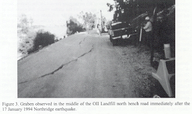
Three of the landfills subjected to some of the strongest shaking in the Northridge event, the Lopez Canyon, Bradley Avenue, and Chiquita Canyon Landfills, had geosynthetic composite liner systems that met Subtitle D requirements. The liner systems at the Lopez Canyon Landfill and the Bradley Avenue Landfill withstood the earthquake without significant damage. However, there was some limited damage to the geosynthetic liner system at the Chiquita Canyon Landfill. The Lopez Canyon Landfill is located within 8.4 km of the fault rapture plane and was subject to an estimated bedrock PHGA of 0.42 g. The Bradley Avenue Landfill is located within 10.8 km of the fault rupture plane and was subject to an estimated bedrock PHGA of 0.36 g. At both sites, local tears in the geotextile overlying the side slope liner were observed by California regulators in post-earthquake inspections (CIWMB 1994). In neither case was the geomembrane liner breached. Furthermore, at both landfills, subsequent investigations by owners representative indicated that the tear was caused by landfill operations prior to the earthquake (GeoSyntecl994; Augello et al. 1995) and was not attributable to earthquake ground motions.
Damage at the Chiquita Canyon Landfill, located approximately 12.2 km from the zone of energy release and subjected to an estimated bedrock PHGA of 0.33 g, may be attributable to a variety of factors, including operational procedures at the landfill, the details of the design, and commonly used construction quality assurance procedures for geosynthetic liners. Damage at this landfill, the only historical seismically-induced damage to a solid waste landfill classified in accordance with Table 1 as Significant Damage, consisted of tears in the geomembrane liner at two locations. In Area C, there was a single tear approximately 4 m in length. This tear is shown in Figure 4. In Area D, there was a series of three parallel tears with a total length of approximately 23 m (EMCON, 1994). Both tears occurred along the crest of benches above the waste parallel to anchor trenches on the benches. Forensic analysis by the Geosynthetic Research Institute (GRI) at Drexel University (GRI, 1994) indicate that the tears initiated from locations where a "coupon" was cut out during construction quality assurance activities for laboratory testing of seam strength. In fact, the tears appear to have initiated from the corner of the rectangular cut-out for the coupon. Stress concentrations due to both the cut-out for the coupon and the anchor trench and stress due to the interim waste configuration all may have been factors in the initiation and propagation of the tear (Anderson and Kavazanjian, 1995; Augello et al., 1995). As the tears were located above the waste and were repairable and as no disruption of the underlying low permeability soil liner was reported, the damage at Chiquita Canyon in the Northridge earthquake did not result in a release of contaminants and did not compromise waste containment. Hence, the damage at Chiquita Canyon is classified as Significant, but not Major, in accordance with Table 1.
![]()
Matasovic et al. (1995a) report that, as in previous earthquakes, the most
prevalent damage to landfills in the Northridge event was surficial cracking
in cover soils, primarily at or near transitions between waste fill and natural
ground areas. Cracks were typically 10 to 70 mm wide and of similar vertical
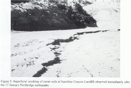
relief. The most pronounced cracking of this type was at the unlined Sunshine
Canyon Landfill, the closest landfill to the fault rupture plane. At that landfill,
where the bedrock PHGA was estimated to be between 0.46 g (Idriss, 1993 attenuation
relationship) and 0.65 g (Abrahamson and Silva, 1997 attenuation relationship
assuming the site is on a hanging wall of thrust fault), the observed cracks
were approximately 300 mm in height and width. Figure 5 shows the largest cracks
that were observed at this facility. The cracks occurred near
the contact between the refuse fill and the canyon wall at the back of the landfill.
This crackingcan be attributed to the differential dynamic response of the waste
fill and the natural ground, and, possibly, earthquake-induced settlement of
the cover soil and/or refuse.
As in previous earthquakes, disruption to landfill gas recovery systems was relatively common among landfills near the epicentral region of the Northridge earthquake. Loss of power was perhaps the most common source of gas system disruption, followed by breakage of gas and condensate lines and well heads. In all cases, gas recovery systems were reportedly repaired by landfill maintenance personnel and back in operation within 24 hours of the earthquake without disruption to landfill operations.
Other Earthquakes
Records of post-earthquake damage inspections of solid waste landfills after
several smaller magnitude earthquakes than the Santa Rosa events and after one
large magnitude but distant event also exist. Some of these events, including
the Pasadena, Malibu, Mojave Desert, and M 7.3 Landers earthquake, are
summarized in Table 3. Damage induced at solid waste landfill facilities by
these events was generally Little to No Damage or Minor (categories I and II,
see Table 1) and therefore neither significant nor useful for engineering back
analyses. However, the strong motion data recorded in a series of small earthquakes
at the OII Landfill provides valuable information on landfill amplification
potential.
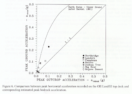
Table 3 presents the characteristics of seven earthquakes of M 5 or greater recorded by the strong motion instrumentation at OII Landfill. Also provided in Table 3 are approximate site-to-source distances and the corresponding bedrock PHGA estimates obtained by the Idriss (1993) attenuation relationship. These estimates are in good agreement with the corresponding bedrock PHGA estimates obtained by one dimensional deconvolution of the motions recorded at the OII landfill base station in these events (Matasovic and Kavazanjian, 1998). All of the bedrock PHGA estimated by deconvolution fell within the 16th and 84th percentile bounds of the Idriss (1993) attenuation relationship. The largest discrepancy, a discrepancy of approximately � 20 percent from the mean value, was for the previously discussed 17 January 1994 Northridge Earthquake.
The mean value bedrock PHGA estimates from the Idriss (1993) attenuation relationship are plotted against the peak acceleration values (average of two horizontal components) recorded at the top deck of the landfill in Figure 6. Also shown in Figure 6 is an "upper bound" curve developed by Harder (1991) by comparing peak acceleration values recorded in bedrock at the base and/or abutment of an earth dam to the transverse peak acceleration at the crest the from both Loma Prieta and several other United States earthquakes.
Figure 6 indicates that the PHGA from both near-field and far-field strong ground motions can be significantly amplified by solid waste materials (base to top deck amplification factors up to 3). This observation is consistent with the results of Fourier analyses by Hushmand et al. (1990) of the Pasadena and Malibu motions recorded at OII site, which indicated Fourier amplification factors of 10 to 12 at the predominant period of waste mass. Figure 6 further indicates that the data recorded at the OII landfill are enveloped by the upper bound of data recorded at earthen dams. However, in the PHGA range that is generally of interest for design of solid waste landfills (0.15 g < PHGA < 0.6 g), recorded observational data are lacking.
Table 3. Earthquake parameters, corresponding bedrock PHGA estimates, and PHGAs
recorded on top deck of OII Landfill
| Earthquake |
Moment Magnitude |
Style of Faulting |
Site-to- Source Distance |
PHGA Estimated at Base |
PHGA Recorded at Top Deck |
|---|---|---|---|---|---|
| Pasadena (3 December 1988) |
5.0 | Strike- Slip |
13 km | 0.075 g | 0.105 g |
| Malibu (19 January 1989) |
5.0 | Thrust | 50 km | 0.018 g | 0.009 g |
| Joshua Tree (23 April 1992) |
6.1 | Strike- Slip |
163 km | 0.006 g | 0.017 g |
| Landers (28 June 1992) |
7.3 | Strike- Slip |
140 km | 0.032 g | 0.085 g |
| Big Bear (28 June 1992) |
6.4 | Strike- Slip |
119 km | 0.015 g | 0.049 g |
| Mojave Desert (11 July 1992) |
5.5 | Strike- Slip |
131 km | 0.004 g | 0.012 g |
| Northridge (17 January 1994) |
6.7 | Thrust | 43 km | 0.104 g | 0.230 g |
CONCLUSIONS
The record of performance of solid waste landfills in California earthquakes is from good to excellent. However, only three landfills lined with geosynthetic liner systems designed in compliance with modern (e.g., EPA Subtitle D) standards have been subjected to strong ground shaking (bedrock PHGA in excess of 0.3 g) in a large magnitude (M 6.7) earthquake. Two of these landfills withstood the earthquake without damage to the liner system or disruption to landfill operations. The third landfill did suffer some limited damage to the containment system, but it was above the waste and did not result in a release of contaminants to the environment. Damage observed to the liner system of that third landfill, subjected to ground motions of lesser intensity than either of the other two geosynthetic-lined landfills, may be attributable to landfill operations, anchoring, details for the liner system, and construction quality assurance procedures. The observed damage at Chiquita Canyon indicates the importance of attention to these details in design, construction, and operation of geosynthetic lined landfills.
Observations at the one landfill in which strong ground motions have been recorded
in several recent earthquakes, the OII Landfill, indicate that significant amplification
of both peak and spectral accelerations can occur in solid waste landfills.
The amplification was especially pronounced for motions from a strong distant
earthquake which generated low intensity but low frequency/long duration motions
at the site. These observations, combined with the post-earthquake damage assessments
at landfills shaken with estimated bedrock PHGA in excess of 0.4 g, indicate
that the shear strength of solid waste landfill materials may be, despite their
relatively large amplification potential, significant. Seismically induced damage
to one geosynthetic liner and cracking of cover soils at numerous solid waste
landfills combined with the potential for amplification of ground motions by
the waste mass and the fact that no landfill with a geosynthetic cover has ever
been subjected to strong ground motions indicate that, despite the general observation
of the good to excellent performance of solid waste landfills in past earthquakes,
attention is warranted in the design of modern, geosynthetic-lined and/or covered
landfills in areas of high seismicity.
ACKNOWLEDGMENTS
Financial support for the work described in this paper was partially provided
by the National Science Foundation under the grant CMS-9422161. This support
is gratefully acknowledged. The authors also wish to thank to Ms. Beth Gross
and Drs. Tarik Hadj-Hamou and Angela El-Telbany, of GeoSyntec Consultants who
reviewed the manuscript and provided many valuable suggestions, and Mr. Richard
Brklacich who assisted with preparing the final version of the manuscript.
REFERENCES CITED
Abrahamson, N. A. and Silva, W. J., 1997, Empirical response spectral attenuation relations for shallow crustal earthquakes, Seismological Research Letters, 68, No. 1, 94-127.
Anderson, D. G. and Kavazanjian, E. Jr., 1995, Performance of landfills under seismic loading, Proc. 3rd International Conference on Recent Advances in Geotechnical Earthquake Engineering and Soil Dynamics, St. Louis, Missouri, 3, 277-306.
Anderson, R. L., 1995, Earthquake related damage and landfill performance, In: Earthquake Design and Performance of Solid Waste Landfills, ASCE Geotechnical Special Publication No. 54, 1-16.
Augello, A. J., Matasovic, N. Bray, J. D., Kavazanjian, E., J., and Seed, R. B., 1995, Evaluation of solid waste landfill performance during the Northridge earthquake, In: Earthquake Design and Performance of Solid Waste Landfills, ASCE Geotechnical Special Publication No. 54, 17-50.
Barrows, A. G., 1975, Surface effects and related geology of the San Fernando earthquake in the Foothill region between Little Tujunga and Wilson Canyons, In: Oakeshott, Gordon B., Ed., San Fernando, California Earthquake of 9 February 1971, California Division of Mines and Geology Bulletin 19, Sacramento, California, 97-117.
Buranek, D. and Prasad, S., 1991, Sanitary landfill performance during the Loma Prieta earthquake, Proc. 2nd International Conference on Recent Advances in Geotechnical Earthquake Engineering and Soil Dynamics, St. Louis, Missouri, 1655-1660.
CIWMB, 1994, Observations of landfill performance, Northridge earthquake of January 17, 1994, California Integrated Waste Management Board, Closure and Remediation Branch, Sacramento, California, 4 p. (plus attachments).
Davis, T. L., Namson, J. and Yerkes, R. F., 1989, A cross section of the Los Angeles area: seismically active fold and thrust belt, the 1987, Whittier-Narrows earthquake, and earthquake hazard, Journal of Geophysical Research, 94, No. B7, 9644-9664.
Dolan, J. F, Shieh, K., Rockwell, T. K., Yeats, R. S., Shaw, J., Suppe, J., Huftile, G. J. and Gath, E. M., 1995, Prospects for larger or more frequent earthquakes in the Los Angeles metropolitan region, Science, 267, 199-205.
EMCON, 1994, Northridge earthquake seismic evaluation, Chiquita Canyon Landfill, Technical Report to Laidlaw Waste Systems, EMCON Associates, San Jose, California.
GeoSyntec, 1994, Assessment of the performance of the Disposal Area C liner system during the Northridge earthquake of 17 January 1994, and of damage to the geotextile and geonet observed on 18 January 1994, Lopez Canyon Sanitary Landfill, Lake View Terrace, Los Angeles, Memorandum to the Solid Waste Management Division, Bureau of Sanitation, City of Los Angeles, prepared by GeoSyntec Consultants, Huntington Beach, California, 18 February.
GRI, 1994, Evaluation of an high density polyethylene geomembrane exhumed from Canyon C, Technical Report, Geosynthetic Research Institute, Drexel University, Philadelphia, Pennsylvania, 29 April.
Harder, Jr., L. S., 1991, Performance of earth dams during the Loma Prieta earthquake, Proc. 2nd International Conference on Recent Advances in Geotechnical Earthquake Engineering and Soil Dynamics, St. Louis, Missouri, 3, 1613-1629.
Hushmand B., Anderson, D. G., Crouse, C. B. and Robertson, R. J., 1990, Seismic monitoring and evaluation of a solid waste landfill, Proc. 4th U. S. National Conference on Earthquake Engineering, Palm Springs, California, 3, 855-863.
Hushmand, 1994, Landfill response to seismic events, Report prepared for the EPA Region IX, Hushmand Associates, Laguna Niguel, California.
Idriss, I. M. and Sun, J. I., 1992, SHAKE91 - a computer program for conducting equivalent linear seismic response analyses of horizontally layered soil deposits, User's Manual, Center for Geotechnical Modeling, Department of Civil and Environmental Engineering, University of California, Davis, California, 13 p. (plus Appendices).
Idriss, I. M., 1993, Procedures for selecting earthquake ground motions at rock sites, Report NIST GCR 93-625, U. S. Department of Commerce, National Institute of Standards and Technology, Gaithersburg, Maryland.
Johnson, M. E., Lundy, J., Lew, M. and Ray, M. E., 1991, Investigation of sanitary landfill slope performance during strong ground motion from the Loma Prieta earthquake of October 17, 1989, Proc. 2nd International Conference on Recent Advances in Geotechnical Earthquake Engineering and Soil Dynamics, St. Louis, Missouri, 1701-1706.
Matasovic, N., Kavazanjian, E. Jr., Augello, A. J., Bray, J. D. and Seed, R. B., 1995a, Solid waste landfill damage caused by 17 January 1994 Northridge earthquake, In: Woods, Mary C. and Seiple, Ray W., Eds., The Northridge, California, Earthquake of 17 January 1994: California Department of Conservation, Division of Mines and Geology Special Publication 116, Sacramento, California, 221-229.
Matasovic, N., Kavazanjian, E. Jr. and Abourjeily, F., 1995b, Dynamic properties of solid waste from field observations, Proc. lst International Conference on Earthquake Geotechnical Engineering, Tokyo, Japan, 1, 549-554.
Matasovic, N. and Kavazanjian, E., Jr., 1998, Cyclic characterization of OII Landfill solid waste, ASCE Journal of Geotechnical and Geoenvironmental Engineering, 124, No. 3, 197-210.
NRT, 1995, Northridge earthquake of January, 17, 1994, Reconnaissance Report EERI, Publication 95-03 (Supplement C to Vol. 11 of Earthquake Spectra), Northridge Reconnaissance Team, Earthquake Engineering Research Institute, Berkeley, California, 523 p.
Oakeshott, G. B., 1975, Geology of the epicentral area, In: Oakeshott, Gordon B., Ed., San Fernando, California Earthquake of 9 February 1971, California Division of Mines and Geology Bulletin 19, Sacramento, California, 19-30.
Orr, W. R. and Finch, M. O., 1990, Solid waste landfill performance during Loma Prieta earthquake, Geotechnics of Waste Fills - Theory and Practice, ASTM STP 1070, 22-30.
Siegel, R. A., Robertson, R. J. and Anderson, D. G., 1990, Slope stability investigation at a landfill in southern California, Geotechnics of Waste Fills-Theory and Practice, ASTM STP 1070, Philadelphia, Pennsylvania, 259-284.
Stewart, J. P., Bray, J. D., Seed, R. B. and Sitar, N., 1994, Preliminary report on the principal geotechnical aspects of the January 17, 1994, Northridge earthquake, Report No. UCB/EERC-94/08, College of Engineering, University of California at Berkeley, Berkeley, California, 238 p.
USGS, 1989, Lessons learned from the Loma Prieta, California, earthquake of
October 17, 1989, In: G. Plafker and J. P. Galloway, Eds., USGS Circular
1045, United States Geological Survey, Menlo Park, California.
Article reprinted from:
Matasovic, N., Kavazanjian, E. Jr., and Anderson, R. 1998, Performance of solid waste landfills in earthquakes, Earthquake Spectra, Issue #2, Vol. 14, p. 319-334.
(NM, EK, Jr.) GeoSyntec Consultants, 2100 Main Street, Suite 150, Huntington
Beach, CA 92648
(RLA) California Integrated Waste Management Board, 8800 Cal Center Drive, Sacramento,
CA 95826
This article was used with permission from the Earthquake Engineering Research Institute.